If you want the best chances for help via ARRUMBA, a little preparation is in order. This falls into three main classes: advance planning, publicity, and day-before-departure.
The advance planning portion is a matter of community service, really. You are a member of a much wider community with members who could be in an emergency situation without any advance warning, and having lost all telephone communications. Every one in this community can strengthen the advantages of ARRUMBA by helping locate good transmission points in various areas.
For example, whenever you seek seclusion outdoors, make sure you have your radio programmed for the repeaters likely to be operating around that area, with the correct CTCSS codes (or “tones”). Take along your radio and cellphone, and select a few points likely to be seen from far away. (Do not underestimate your HT’s range; I have been halfway up a mountain with a 5-Watt HT, and had a report of “loud and clear” from a listener whose repeater was on another mountain a full 13 air miles away.) Then set your HT on scan, and see if you hear any repeaters (they issue automatic ID signals periodically, often in Morse code) or any voice chatter.
Whether you hear one or not, next make one or two brief transmissions asking for a signal check on the channels you think most likely. If, anyone replies, bingo! Thank her/him, repeat your call sign, and say “clear” to show that you will stop occupying the channel. But don’t stop there. Now write down your location in words (your own description, such as “Dry Creek at Oakville Grade” or whatever is appropriate and memorable to you), and use your cellphone to get your coordinates. Write down those coordinates too, as well as the frequency you just used, and your signal report (“loud and clear”, or “weak”, or whatever you were told). If you like, later on you can use Google Maps Engine Lite to place these spots on a map.
Now you have the makings of a highly useful ARRUMBA database. Collect a few of these readings (especially the ones with good signal reports) and take a copy with you whenever you are on expedition. All it takes is a list (or Excel spreadsheet) with headings like this:
Place Coords Freq Remarks
You could be even more help if you posted your list at trailheads, or club rooms, or on your interest-group social media pages. In fact, with a social media page you can share with everyone, and vice versa.
Now the publicity part. This is relatively simple, and it should add to your web of signaling points. When you are out and about, just talk about ARRUMBA as a safety net for all your fellow explorers or country-dwellers. The more who know about it and understand the principles, the better for all. And when you meet folks who already have their call sign, ask them to consider collecting signal data in their favorite haunts and sharing it.
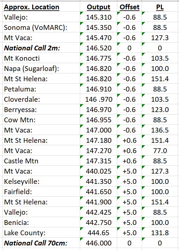
Finally, the day-before-departure part. Review how to operate your radio! Make sure it is programmed for the repeaters you expect to find in your area, and the available simplex frequencies. Take your locations+frequencies list. (Here’s an example for Napa County, California:)
Fully-charge the batteries. Put a tether on your HT, so it cannot fall off your belt. Make sure your smartphone is fully charged just before you set off. Find that old cellphone, and charge it up too, so you have a backup position-finder.
Ahh, now just relax. You are traveling smart, and you can communicate even off the grid!
| Previous Page | Next Page |